Environmental Health Data
Where people work, live, and play can dramatically affect their health. Environmental health "addresses the physical, chemical, and biological factors external to a person, and all the related factors impacting behaviors" (World Health Organization). These topics include things like air quality, water quality, the built environment, and consumer product exposures.
In 2017, we updated the 2015 Central Oregon Regional Health Assessment (RHA) with new data. This page provides an overview of updated data on environmental health. Please read through the information below, or download the environmental health overview handout from the supporting documents section at the bottom of the page.
You can find additional data related to environmental health, as well as information on a variety of other health topics in the Regional Health Assessment Midpoint Update document.

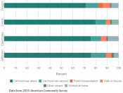
Means of transportation to work (Click for larger image)
The American Community Survey (ACS) is conducted annually by the federal government, and it provides us with important information about our community and the people who live in Central Oregon. Data from the ACS tells us about how people typically commute to work, including whether they use vehicles or active transportation. Most Central Oregonians commute to work alone in a car, truck, or van. In fact, less than 5% of residents in Crook, Deschutes, or Jefferson county use active commuting (like walking or riding a bicycle).

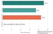
Average travel time to work (Click for larger image)
Although most of us commute to work alone in a car, truck, or van, data from the ACS indicates that most Central Oregonians spend less time commuting than Oregonians as a whole. In Deschutes County, the average commute time was 21.3 minutes; in Crook County, it was 18.5 minutes.

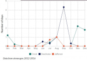
Federal, state, and local agencies work together to create and support airnow.gov, which provides data about local air quality across the United States. This data can be used to monitor unhealthy air quality thresholds for populations with certain health conditions. In Deschutes and Jefferson County, late summer is the time of year with the highest number of unhealthy air quality for those with asthma and lung diseases. For Crook County, winter has the highest average number of unhealthy air quality days.

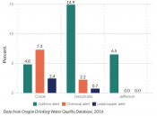
Percent of all active drinking water systems with an alert (Click for larger image)
In Oregon, drinking water system quality can be found in the Oregon Drinking Water Quality Database. The database includes information on drinking water system alerts. In Deschutes and Jefferson Counties, coliform alerts (which include a variety of different types of bacteria) were the most common type of alerts seen. In Crook County, chemical alerts were the most common type of alerts seen.
